It’s a water fountain. Unless you’re drinking something other than water out of it.
4 Likes
I live in the Milwaukee area, there’s a real chance at least part of it is lead.
8 Likes
(RC Cola land)
2 Likes
Is this a request for feet pics? If so I can drop into the SR.
Otherwise, shoes. Shoes are on my feet. My office camo crocs to be exact. Not sneakers, or gym shoes, just shoes.
3 Likes
Just purging our history.
Think we covered, feet pics are for Silk Road and DMs to the Roost captain.
5 Likes
This model always provides the coldest, metal filled water.
2 Likes
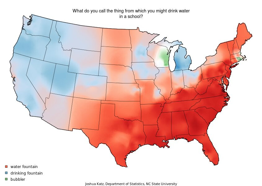
Friend of mine swears it’s a bubbler. Luckily we agree that it’s duck duck goose and not duck duck grey duck like those damn loons in MN
5 Likes
A bubbler is a real thing, but what you pictured isn’t it. Not even sure the disgusting thing that is a bubbler even exists anymore, thankfully.
Also, I love that, that article agrees with me it’s called a “drinking fountain” @Setwilli.
7 Likes
As a North Carolina native and also an article written by an NC State employee, I will still call it a water fountain.
3 Likes
Only the southeast corner of the state commits this offense.
3 Likes
As a Michigander I am very intrigued as to how and why we adopted drinking fountain because it’s definitely what we say.
You do not want to drink out of a bubbler I can assure you that.
3 Likes
Look, you just stick to getting booze at your party stores, and everyone else in the country will conveniently buy booze at convenience stores. Now if you’ll excuse me, I need to do some local travel, and as a Southern Californian, I will refer to all of the freeways with the definite article followed by the highway number. Hope the traffic on The 88, the 290, and the 94 isn’t too bad.
9 Likes
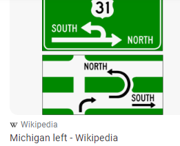
Take advantage of the freedom to make left turns.
3 Likes
WTF is wrong with us.
4 Likes
I dont know where you guys stand on this but I only know the roads by # and not name
6 Likes
While that is truly liberating, it is somewhat tempered by the restrictions on making right turns on red at a vast number of the City’s intersections. However, the ability to make left turns while yielding on greens in Chicago is far superior to California’s ridiculous adherence to red arrows on left turns.
1 Like
Don’t forget about Jean Baptiste Pointe du Sable Lake Shore Drive
5 Likes
I’ve been here long enough to know both, but what threw me for a loop at first were the traffic reports on the radio all using travel times. Telling me how long it was going to take to get from Lake Cook to the Junction didn’t help when I didn’t know where Lake-Cook OR the Junction were (also was always wondering where the actual Lake Cook was until I learned there was no Lake Cook). I was used to the traffic reports in the greater L.A. area that told you specifically where accidents or other slow downs were occurring (hint: pretty much everywhere). Then I realized it was largely because depending on what direction your coming from, there’s basically one way in and one way out of downtown. Like if you’re in Highland Park, it’s kind of hard to avoid the Edens if you’re headed downtown, so they may as well tell you how bad it’s going to be.
Contrast that with L.A., which has like 6 or 7 kind of big downtowny areas, and a large grid of freeways that you can mix and match to get to your destination. I lived around Pasadena and had a summer internship in Santa Ana. With no traffic I’d take the 10 to the 605, to the 5, to the 22. But If there was an accident on the 605, I could take the 10 or the 60 to the 57, go around the accident, and hook back up to the 5 right about where it hits the 22. That was valuable intel if I wanted to save a good 45 seconds or so. This was all pre-Waze of course.
2 Likes
9 Likes
I didn’t know it was called anything other than a bubbler until high school.
5 Likes